
© Joe Douglas. 2017
It was possible, but forbidden by parents, to scramble down to the river edge from the bottom of bridge Street. As we got bigger one of the challenges was to wade across the river to the Mill Fields ,now called the Memorial Gardens. As you waded through the water you reached a point where you stepped into water that was noticeably warmer. This is where you moved from the Cocker water and into the Derwent water. It was possible to stand with one leg in each, one leg cold and the other one warm.
The difference in temperature is simply because the Cocker is a much shorter river with smaller lakes and the water gets from running off the fells to Cockermouth quicker.
The 1940’s bridge consisted of two connected sides with a wooden floor between them. I remember the bridge walk way consisted of wooden planks 2 inches thick and 6 or eight inches wide fitting into metal channels, one at each end. There was no central support under the planks and the you could see the river through the gaps between them. It was quite nerve wracking looking through the gaps at the river in full spate. The sides of the bridge had a flat top supported on posts. with strip steel trellis underneath. I remember the spaces in the lattice being big enough for an average dog to squeeze through. The Health and Safety brigade would certainly have condemned it.
The bridge was, and still is, the main access to the mill area from the town and was heavily used mornings, lunchtimes and evenings as the mill workers went to and from work. Occasionally a plank would fail and close the bridge for repairs. All the workers had to go via the Gote Bridge which is a considerable diversion. It was also used by holders of the very productive allotments that are now underneath the current car park. My father, grandfather and uncle had allotments and grew a considerable amount of vegetables for the family. Their allotments stretched from the mill race to the lane.
The allotments were fertilized with ‘local produce’ and I can remember wandering round Mickle Brows collecting sheep ‘parples’, (droppings), that were soaked in a huge steel drum to provide a liquid fertilizer.
About quarter of a mile upstream from the castle was the dam that fed the mill race. The dam included a fish ladder where some very large salmon could be seen travelling upstream.
The pool behind the dam was a favourite place for swimming. Click on this link to find out more.
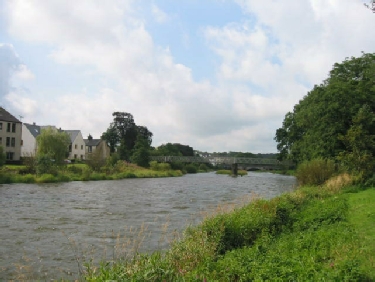
The photograph shows the scene today. None of the green area on the far side of the river, or the green islands were there in the 1940’s and 50’s’.
Mill Bridge and River Derwent Memories of the 1940’s
The river Derwent, between the mouth of the Cocker and Low Sand Lane, was part of the play area in the later 1940’s when I lived in Bridge Street. In those days the bridge was a much simpler structure than the the one that spans the river today. The stone pillars are the same but the frame and footpath have been changed dramatically.
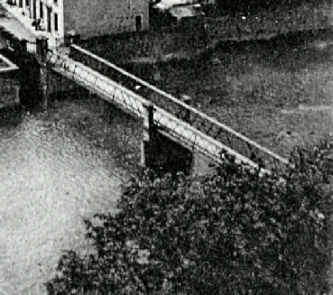
The Photograph is cut from a Post Card posted by Jenni Rushton on the ‘Old Cockermouth’ Facebook page on 11th August 2015.
Use this link to see the full picture. Click on the picture to return.
The river was much wider back then. The riverside from the end of Waterloo Street to Low Sand Lane was a track that was only about 2 feet above the normal river level. The track was about one and a half car widths wide. Normally there was flowing water between the edge of the track and the first pillar out from Bridge Street.
Today the river bank has been extended outwards and built up well out towards the first pillar and gardens etc. behind the properties have been extended as far downstream as the Gote bridge. As a rough estimate I think the ground level has been raised by at least 6 feet and what was just a track is now a wide green area edged with trees at the waterside. The result of this expansion is that the width of the river bed is only about 75% of what it was.
. I wonder what part that plays in any flooding?
Click on the picture to zoom